


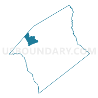
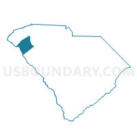
Mount Tabor Voting District, Anderson County, South Carolina
About
Outline

Summary
| Unique Area Identifier | 664966 |
| Name | Mount Tabor Voting District |
| County | Anderson County |
| State | South Carolina |
| Area (square miles) | 18.26 |
| Land Area (square miles) | 15.97 |
| Water Area (square miles) | 2.29 |
| % of Land Area | 87.46 |
| % of Water Area | 12.54 |
| Latitude of the Internal Point | 34.58126330 |
| Longtitude of the Internal Point | -82.81628450 |
Maps

Graphs
Select a template below for downloading or customizing gragh for Mount Tabor Voting District, Anderson County, South Carolina


Neighbors
Neighoring Voting District (by Name) Neighboring Voting District on the Map
- Denver-Sandy Springs Voting District, Anderson County, SC
- Fork No. 1 Voting District, Anderson County, SC
- Friendship Voting District, Oconee County, SC
- La France Voting District, Anderson County, SC
- Pendleton Voting District, Anderson County, SC
- Shiloh Voting District, Oconee County, SC
- Stone Church Voting District, Pickens County, SC
- Townville Voting District, Anderson County, SC
Top 10 Neighboring County Subdivision (by Population) Neighboring County Subdivision on the Map
- Seneca CCD, Oconee County, SC (25,923)
- Clemson CCD, Pickens County, SC (19,753)
- Pendleton CCD, Anderson County, SC (17,948)
- Townville CCD, Anderson County, SC (4,085)
Top 10 Neighboring Unified School District (by Population) Neighboring Unified School District on the Map
- Pickens County School District, SC (119,224)
- Oconee County School District, SC (74,273)
- Anderson School District 4, SC (21,359)
Top 10 Neighboring State Legislative District Lower Chamber (by Population) Neighboring State Legislative District Lower Chamber on the Map
- State House District 2, SC (37,913)
- State House District 6, SC (37,254)
- State House District 3, SC (36,002)
- State House District 8, SC (35,520)
Top 10 Neighboring State Legislative District Upper Chamber (by Population) Neighboring State Legislative District Upper Chamber on the Map
Top 10 Neighboring 111th Congressional District (by Population) Neighboring 111th Congressional District on the Map
Top 10 Neighboring Census Tract (by Population) Neighboring Census Tract on the Map
- Census Tract 106, Anderson County, SC (7,409)
- Census Tract 307.02, Oconee County, SC (6,086)
- Census Tract 107, Anderson County, SC (5,741)
- Census Tract 112.02, Pickens County, SC (5,694)
- Census Tract 108, Anderson County, SC (4,798)
- Census Tract 109, Anderson County, SC (4,085)